


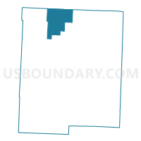
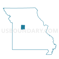
Houstonia Voting District, Pettis County, Missouri
About
Outline

Summary
| Unique Area Identifier | 609339 |
| Name | Houstonia Voting District |
| County | Pettis County |
| State | Missouri |
| Area (square miles) | 30.39 |
| Land Area (square miles) | 30.27 |
| Water Area (square miles) | 0.12 |
| % of Land Area | 99.61 |
| % of Water Area | 0.39 |
| Latitude of the Internal Point | 38.89982640 |
| Longtitude of the Internal Point | -93.34336800 |
Maps

Graphs
Select a template below for downloading or customizing gragh for Houstonia Voting District, Pettis County, Missouri


Neighbors
Neighoring Voting District (by Name) Neighboring Voting District on the Map
- Hughesville Voting District, Pettis County, MO
- La Monte/Blackwater Voting District, Pettis County, MO
- Liberty Voting District, Saline County, MO
- Longwood/Heath Creek Voting District, Pettis County, MO
- Salt Pond Voting District, Saline County, MO
Top 10 Neighboring County Subdivision (by Population) Neighboring County Subdivision on the Map
- Salt Pond township, Saline County, MO (2,035)
- Longwood township, Pettis County, MO (610)
- Liberty township, Saline County, MO (601)
- Hughesville township, Pettis County, MO (520)
- Houstonia township, Pettis County, MO (436)
- Blackwater township, Pettis County, MO (393)
Top 10 Neighboring Place (by Population) Neighboring Place on the Map
Top 10 Neighboring Unified School District (by Population) Neighboring Unified School District on the Map
- Sweet Springs R-VII School District, MO (2,869)
- Pettis County R-V School District, MO (2,174)
- La Monte R-IV School District, MO (1,950)
Top 10 Neighboring State Legislative District Lower Chamber (by Population) Neighboring State Legislative District Lower Chamber on the Map
- State House District 118, MO (36,454)
- State House District 117, MO (35,534)
- State House District 26, MO (33,935)
Top 10 Neighboring State Legislative District Upper Chamber (by Population) Neighboring State Legislative District Upper Chamber on the Map
Top 10 Neighboring 111th Congressional District (by Population) Neighboring 111th Congressional District on the Map
Top 10 Neighboring Census Tract (by Population) Neighboring Census Tract on the Map
- Census Tract 4802, Pettis County, MO (5,867)
- Census Tract 4801, Pettis County, MO (4,061)
- Census Tract 907, Saline County, MO (2,715)
- Census Tract 908, Saline County, MO (2,575)